Showing posts with label wet. Show all posts

11 July 2019

summer deferred

Here on the hill-top we await the sequel to summer. Late spring was dry and warm, but as we approach mid-July we sit under clouds and showers. We've had almost 3/4" this past few days, nearly the average July in a hurry. No matter, the thrush and grosbeaks still sing and flowers continue to bloom - probably with more enthusiasm than usual!

In the meantime the large yard goes unmown. That is partly due to rain but also to a flat tire on the riding mower. I finally have a spare in hand, but no rush to put it on while showers remain. Once the dry weather resumes I'll definitely have my yardwork cut out for me.

I have yet to attack the blackberry hillside, but I've a better tool for it at least. A rechargable 18v trimmer also awaits better weather, and I have blades to replace the string for more effective vine removal. We'll see how that goes.

Among other items that have been accomplished though, is the stone walk below the deck. It looks nice, far better now that some weed-block fabric sits below it! A nice place to walk, and also less of a hassle when the mower comes out - that corner of the yard was always awkward to get trimmed..

I've also trimmed several trees back, and relocated the weather gage to a spot with fewer branches overhanging it to mess with my rainfall totals.

03 April 2019

long time no see


This has not been a feature of the 2018-9 wet season. It's definitely rather typical in November-January rather than April, and the amounts will not be huge; still, it's something. After a March that was just 41% of average, we'll take it!

Our Oct-Mar 'wet season' total was 84% of average, which is the first time in four or more years that we've been subpar. The weekly total is forecast to be about three inches, so no flooding or damage - but with April normal at just over 5", we may be in the above-average category for a week or two.

26 October 2018

cancel that..

After two inches of rain in two days, and another inch coming in the next 36 hours, October will be above average with four days to go. It's really unlikely that we will get to ten inches.. but I'm done with strong expectations about the fall rainy season!

11 January 2018

radar updates & poor timing

The heaviest rain has now arrived in Portland. Sadly KRTX is not back for it, and KLGX is sporadic. We've had nearly an inch, but it's been easier to look out the window than to check the internet. Nothing wrong with that, as long as you aren't making plans for a good time to go outside soon!


Messages from the NWS radar status page:

MESSAGE DATE:  JAN 11 2018 01:25:00
THE KLGX RADAR PLANNED SERVICE LIFE EXTENSION PROJECT WILL COME TO AN END TODAY (THURSDAY) AND THE RADAR IS EXPECTED TO RETURN TO SERVICE.


Message Date:  Jan 10 2018 23:47:03
KRTX will be operating in a degraded mode overnight, through 9am PST/ 17z Jan 11


29 December 2017

a lot but not enough

No not my Christmas gifts, the rain!

December had a ten-day stretch of cool dry weather, which immediately put the month far behind normal. The cold and ice came at Christmas-time to keep things sub-par.

Then we tried to catch up.
We had nearly 2 inches yesterday and have 1.8" today. The forecast was for about 2½ inches in these two days, so we're overperforming. Another dry stretch will close out the month and year once this storm passes completely. That will leave us an inch short, which is pretty surprising considering the number of dry days!

Since we are still about six inches high for Oct-Dec, it is not at all a big thing.. just a thing.


10 November 2017

November being itself

According to the 30-year normals in the PRISM database, November is our wettest month with over 10½ inches on average. We're doing just fine in that regard, ten days in - and much more is coming soon!

Much of the coming week's precipitation is coming with cool air, therefore snow in the mountains will measure several feet by Thanksgiving. Ski areas will rejoice, and skiers as well.

Since we're over 3½" already and this forecast graphic for the next seven days is for ~six additional inches, it appears that November will be an average damp month at the very least. December and January average over nine inches each so the wet season has just begun.. again.

The yard is quite covered in maple leaves, but the trees are not done dropping their loads. The vine maple is still holding on but the best colors have now passed. The prettiest days of autumn are passed, and the clouds are definitely in charge.

11/18 UPDATE - the six inches did not materialize but we're still on track for a normal month. We received quite a lot of rain at times but not quite at the predicted times. Today was pretty but it goes downhill again tomorrow. Just an ordinary November..

03 November 2017

chance of ..snow!

We've now dropped into the mid-30s at night, and soon our clocks fall back an hour. No daylight to save any more so why not - I'd still prefer a half-hour step and lock it down. I'm funny like that.

Areas of NW Washington got some snow this morning! Not much in general but the traditional perfect-storm pattern has set up with cold air and a pinch of over-water moisture fetch. /Charts and details here./  Sunday night shows our best chance at 800' in SW Washington, we'll see how that goes.

I've often seen snow around Thanksgiving in my lifetime, but closer to Halloween? Not often.

23 October 2017

My Wettest Days!

After the past few damp days I decided to wander into the virtual NWS archives in Portland. Sure enough, several days of up to 2½ inches have happened there in my lifetime - but nothing in the 3-5 inch category there.

Considering that Thursday was also a top-ten rainfall day (#9 as of now), that's mighty impressive. A year or two ago I was shocked by 10 inches in a single week (November 2015) - now I can add eight-plus inches in a 4-day span to that list of amazing rainfall.

Several interesting points about atmospheric rivers to be seen. Often times the warm front would dump a bunch, move just north of my location then swing south again - so a gap of a day or two between large numbers. Either that or a double river set up from two different dead typhoons?

The tints provide the hint. October 1994 had three events within six days (blue), and our double whammy came on the 19th and 21st this past week. That one was in fact two separate events, so it happens.

Note also the tan events from 1996, which was an amazingly wet year around here. Toss in Nov 11 '95 if you wish.

Another interesting point is that nearly every one of these is a 'recent' event. The earliest are 1960, 1969 and 1973 - then nothing until 1984.

So whatever it may mean.. here it is!

16 October 2017

wet week ahead!

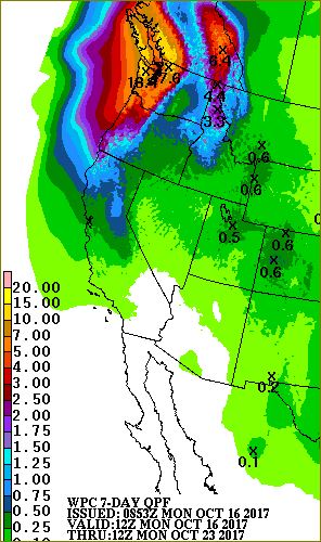
The upcoming week has a full load of rainfall! The image shows the total 7-day amount that's currently forecast, and the moisture plume showing on the IR satellite image confirms that someone is going to get very wet. Even four inches is enough to put us positive for October's total amount, so we needn't fear for our well running dry.

The past few days have been quite nice, with temperatures now reaching the 30s - with just under 11 hours of daylight now, that's no surprise. I rebuilt the wood 'shed' with our largest tarp for a roof/wall and the remaining fiberglass from the previous shed for bonus protection on top. If the wind doesn't get out of hand that should do for a while.

Our wood is going faster than I expected, so a refill in December will need to happen. Hopefully by then our income will be reinforced in one of several ways. We still await word on my wife's Social Security payments that were suspended for reasons not entirely clear, but I'm seeking a part-time job to cover that missing income. We'll get through this spell but retirement will be suspended for a while. It would take a while to qualify for SoSec myself, as I removed myself from the pool very early to enter Federal service. A few years of part-timing will reduce our debts substantially.


*updates - 
  • 10/19 so far so 'good', as yesterday ended with about 2¼ inches of rain. The weekend promises as least two more inches, so mark up another month of above-average precipitation - we've sure had a lot of those in Oct-May months!
  • 10/20 another half-inch, about three more inches now expected beginning early Saturday.
  • 10/21 nearly 5 inches, and 3/4 more Sunday! 

21 September 2017

dry and hot and dry and - oh wait

After a dreadfully dry and decently warm summer, autumn arrived early. We received just under four inches of rain in 3½ days up on the hill-top! Thankfully the home was pretty well prepared: roof was cleaned, gutters emptied and spout-directors reattached before the deluge began. Three straight days of 1+ inches is rather rare around here, most especially in mid-September! A few dry days with morning fog are up next, then we'll see what comes after.

The Eagle Creek fire that has hit many Portland-area residents so hard was weakened considerably by the rainfall, though it's still less than 2/3 contained at this time. Somewhat calm and residual moisture should help to keep it mellow as fire crews get into the hot spots and finish this off. I believe Interstate 84 is still closed for east-bound travel as the danger of slides and large rockfalls will take some serious study to control!

05 September 2017

a surreal 2017 continues

It's been an exceptional year in many ways. Not always good, but definitely riding the tails of the distribution curve!

  • Winter was amazing for its stretches of cold and snow, topped off by the 13 inches on Superbowl Sunday.
  • Spring was absurdly grey and damp - from 1Jul 2016 to 30Jun 2017 we had over 98 inches of rain!
  • Summer had its heat spells, no surprise there. What was decidedly uncommon was the amount of smoke west of the Cascades. A month or more ago it was fires from Canada whose smoke came south, then the past week smoke from southern Oregon came north. 
  • The past three days have seen the Gorge go up in flames, whipped to a frenzy by powerful east winds from Cascade Locks to Corbett. Portland (and even Longview) received a dusting of ash from the fires to our east. So many good memories of Gorge hikes are still intact, but they definitely won't look the same next time.
  • The sun disappeared for about 2 minutes.. but we knew that was coming at least!
  • In-laws in law John and Theo were taken from us in a brief heart-beat; their funeral was today as the ash drifted slowly to earth. Ashes to ashes, dust to dust.
The late afternoon at our home brought the first sign of several hoped-for change in the weather: the west wind arrived and knocked temperatures down 8 degrees in a half-hour, and before sunset temperatures fell into the 60s. Hooray! Next up, a chance of showers - though lightning could accompany them from the remnants of Lidia, which would be very bad. If the wind reverses in the Gorge the fire should fall back to already-charred areas and hopefully become more manageable. As with everything in life: we shall see.


16 November 2015

More weather fun

Another atmospheric river is striking today.  It has a shorter fetch, back to the dateline not Taiwan!
The local area handled the last one fine so no major issues  - though it should be noted that two trees fell across our only route to civilization last weekend.  Good thing it's a popular route, as our electric chainsaw draws more power than our car can supply.. I guess the pruning saw should hang out in the car for non-Christmas-tree cutting?

Speaking of Christmas, our first snow forecast is now showing up in the 10-day forecast.  Unlikely at day 8.. but not impossible!  I feel like early-season snowfall is more common in el Niño conditions, before winter and its common split-flow pattern rears its ugly graphics and the moisture heads elsewhere.  So far so good though, and the weekend snowpack needs to absorb just 24 hours of rainfall before it gets cold again.. we'll see how it goes.  I would not be surprised if some sites already have as much snow as they had all of last winter!  Yes, 2014/15 was that bad.

Update - warm air retreats soon!

I drove into town and got hammered by some seriously strong rain.  Out here it's been almost 1/2" per hour for quite some time, resulting in 9½" in (th fr sa su mo) FIVE DAYS.  And it's still raining hard - but the cold front seems to be on the radar now.  It's broken into several pieces, something we never saw before the KLGX radar came into play.  Nice!
Note winds from the west and NW behind those fine gold bars, mostly south from Centralia south to Astoria.

And here's our gage update.  Whoops it went to 4.1" before I finished the post, 2.82" today and 9.58 this week.


16:30 - we're Winning the War on Weather!

Look at this - a mere 1/2 inch for the wettest day?  Mission Accomplished!

And that was indeed the cold front - it arrived ~15:50 with strong WNW winds breaking limbs and rattling someone else's tin roof nearby.  Our roofs held, but the new woodpile cover almost took flight; I wrestled a framework of steel pipe back into place but left no gap for the wind to lift.  I also put up the tarps, and one was down within about a minute.. so let's leave well enough alone, shall we?

The last hour saw a miserly 0.12" for grand totals of 3.02 since midnight, 9.78 for the week.  Not the month, as I had to reboot my weather system just before the Thursday 11/11 storm - so well over 10 inches for November.  Hey, two wet months in a row - another win!


 p.s. Oh looky here - forecast is still trying
to bring in a pinch of snow next week..


Final report.
As of about 5pm today we crossed the 10-inch line for the week.  From about noon last Thursday to 4pm Wednesday my gage counted 10.03".  Another half inch is expected before noon tomorrow.